
3D Printed Terrain Models
Topography Maps: Elevation Data, 3D Printed at Any Scale.
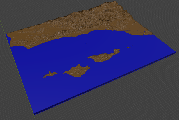
ALT transforms elevation data into precision terrain models — from mountain ranges and watersheds to suburban parcels and bathymetric seafloor maps. Using USGS, LiDAR, and satellite-derived elevation data, we produce physical models that reveal slope, aspect, contour, and drainage in ways no flat map or digital screen can match.
Why physical terrain?
Digital elevation models on a screen are flat by nature. No amount of shading, contour overlay, or 3D rendering conveys the tactile reality of terrain — the steepness of a ridgeline, the drainage pattern of a watershed, or the visual relationship between a building site and its surrounding slope. A 3D printed topography map makes elevation tangible: you can hold it, view it from any angle, read it under directional light, and share it around a conference table. It turns abstract data into something you can touch.
1 m
Best-available LiDAR resolution — captures individual boulders, building footprints, and road cuts with sub-meter accuracy
10 m
USGS national coverage resolution — sufficient for watersheds, mountain ranges, and regional planning models
50:1
Maximum vertical exaggeration ratio — makes subtle terrain features readable without distorting spatial relationships
900 x 1200 mm
Maximum tiled model size — seamless assemblies for large landscapes, master plans, and exhibition displays
Data Sources
From Raw Elevation Data to Printable Mesh
Every topography map begins with elevation data. The quality of the final model depends entirely on the resolution and accuracy of the source data. ALT works with multiple data sources depending on the project's scale, location, and precision requirements:
| Data Source | Resolution | Coverage | Best For |
|---|---|---|---|
| LiDAR (Airborne) | 0.5–2 m | Contiguous US (USGS 3DEP), select global | Urban parcels, infrastructure corridors, floodplain modeling, building-scale terrain |
| USGS 3DEP (1 arc-second) | 10 m | Full US coverage | Watershed analysis, regional planning, trail mapping, recreational areas |
| SRTM (Shuttle Radar) | 30 m | Global (60°N–56°S) | International terrain, mountain ranges, large-scale geographic models |
| Copernicus DEM (ESA) | 30 m | Global | Worldwide coverage, consistent quality, environmental modeling |
| Bathymetric (NOAA, multibeam) | 1–100 m | Coastal US, select seafloor | Seafloor terrain, coastal zones, harbor and channel models |
| Drone Photogrammetry | 1–10 cm | Site-specific (customer-provided or ALT-flown) | Construction sites, golf courses, vineyards, mine pits, archaeological digs |
Vertical exaggeration is applied selectively to make terrain features readable at reduced scale. A 1:50,000 horizontal scale model of a mountain range with 1:1 vertical scale would show a barely perceptible rise. ALT's standard vertical exaggeration ranges from 1.5× to 5× depending on the terrain type and model purpose. For subtle terrain (Midwest farmland, coastal plains), we apply up to 50× exaggeration to reveal drainage patterns and micro-topography.
Applications
Who Uses 3D Printed Topography Maps
Urban & Landscape Planning
Visualize solar exposure, drainage patterns, cut-and-fill volumes, and view corridors before breaking ground. 3D terrain models reveal site constraints — south-facing slopes for passive solar, ridge-line visibility for scenic corridor compliance, and drainage catchment areas for stormwater management — that contour maps obscure and screen views flatten.
Geology & Earth Science Education
Teach topographic map reading, geomorphology, watershed analysis, and structural geology with hands-on models that students can touch, measure, and view from multiple angles. A 3D model of a folded mountain belt makes the relationship between structure and topography immediately legible in a way that 2D cross-sections cannot.
Trail, Recreation & Wilderness Mapping
Memorialize a thru-hike, a favorite climbing area, a surf break bathymetry, or a backcountry ski zone. Models can include trail overlays, elevation profiles, waypoint markers, and land management boundaries — printed as embossed features on the terrain surface.
Environmental & Watershed Analysis
Floodplain managers, wildfire mitigation planners, and conservation organizations use 3D terrain models to communicate risk and proposed interventions at public meetings. A physical model of a post-fire debris flow zone makes evacuation routes and retention basin locations far clearer than any map wall.
Architecture & Site Planning
Site-specific terrain models at 1:500–1:2000 scale showing building footprints, setbacks, grading plans, and vegetation overlays. Essential for design review boards, environmental impact reports (EIRs), and client presentations where site context determines design decisions.
Art, Decor & Commemorative Gifts
Custom terrain models of meaningful locations — the mountain range where you grew up, the coastline of your honeymoon, the peak you summited — printed as gallery-quality display pieces. Choose from white PLA, wood-fill composites, or multi-color elevation maps with color gradients representing elevation bands.
Materials & Finishes
Materials for Topography Models
Material selection affects the look, feel, durability, and cost of your terrain model. ALT offers a curated set of materials specifically suited to topographic printing:
| Material | Look & Feel | Best For | Color Options |
|---|---|---|---|
| White PLA | Matte, uniform, paintable | Planning models, study aids, paintable bases | Single color (any), white default |
| Grey PLA | Neutral, photographs well | Presentation models, professional display | Single color, grey default |
| Wood-Fill PLA | Warm, natural texture | Decorative display, gifts, rustic aesthetic | Natural wood tones, sandable/stainable |
| Color Gradient (Multi-material) | Elevation-colored bands | Educational models, scientific communication | Up to 5 colors, gradient from low to high |
| Sandstone Composite | Textured, geological look | Gallery display, museum exhibits | Warm earth tones, textured finish |
| Translucent PETG | Semi-transparent, lit display | Backlit models, subsurface mapping | Clear or tinted |
Base options: Terrain models can be mounted on CNC-routed wooden bases with engraved labels, scale bars, and north arrows. Framed shadow-box mounts with backlighting are available for translucent materials. Tile assemblies are joined with alignment keys for seamless large-format displays.
Scale & Size
Choosing the Right Scale
The optimal scale depends on what you need to see. Use this guide to match model scale to your application:
| Scale | Real-World Area (typical) | Model Size | Visible Features | Best For |
|---|---|---|---|---|
| 1:250,000 | 100 × 100 km | 400 × 400 mm | Major mountain ranges, regional watersheds | Geographic overview, museum display |
| 1:100,000 | 40 × 40 km | 400 × 400 mm | River valleys, ridge lines, county-scale topography | Regional planning, recreation maps |
| 1:50,000 | 20 × 20 km | 400 × 400 mm | Individual peaks, drainage networks, trail systems | Trail maps, wilderness areas, field study |
| 1:24,000 | 9.6 × 9.6 km | 400 × 400 mm | USGS quadrangle detail, building footprints | Engineering, environmental review |
| 1:10,000 | 4 × 4 km | 400 × 400 mm | Individual buildings, road cuts, parcel boundaries | Site planning, urban design |
| 1:2,500 | 1 × 1 km | 400 × 400 mm | Building-scale terrain, grading, landscaping | Architectural site plans, development review |
Custom sizes: Models can be printed at any size from 100 × 100 mm (desktop display) up to 900 × 1200 mm (tiled wall display). ALT will help you select the scale that balances detail visibility with practical model dimensions.
Workflow
How It Works: From Coordinates to Contours
01 — Define Your Location & Purpose
Tell us where and why. A lat/lng coordinate, a city name, a trailhead, or a property address. Also tell us what the model is for — a planning hearing, a classroom, a gift — so we can recommend the right scale, material, and level of detail.
02 — We Source & Process Elevation Data
Our pipeline ingests raw elevation data from the appropriate source (LiDAR, USGS, SRTM, Copernicus, or customer-provided drone survey). We clip to your area of interest, fill data voids, apply vertical exaggeration, and generate a watertight 3D mesh optimized for printing.
03 — We Optimize for Print
We review the mesh for printability: base thickness, overhangs (cliffs, overhanging rock formations), tile splitting for large models, alignment key placement, and surface texture. We add optional features: contour lines, labeled peaks, trail overlays, north arrows, and scale bars. A digital proof is provided for your approval.
04 — Print, Finish & Mount
Models are printed on our production fleet, post-processed (support removal, surface smoothing), and mounted on your choice of base. Multi-color elevation gradient models are printed with up to 5 material changes per layer. Tiled assemblies are joined with precision alignment keys. Framed and backlit options are assembled in-house.
05 — Ship or Pick Up
Models are packed in custom foam-lined crates with double-wall corrugate. We ship nationwide via FedEx or UPS. Local Santa Barbara clients can pick up from our studio. Typical turnaround: 3–7 days for single-piece models, 7–14 days for large tiled assemblies or multi-color gradient prints.
Pricing Guide
Terrain Model Pricing
Every topography model is built from 225 × 225 mm tiles at a base rate of $75 per tile. Larger models use more tiles in a grid; all tiles are precision-aligned with embedded alignment keys for seamless assembly. Pricing scales predictably by tile count:
| Tile Grid | Total Size | Tiles | Tile Price | Data Source | Lead Time |
|---|---|---|---|---|---|
| Single Tile | 225 × 225 mm | 1 | $75 | USGS 10 m / SRTM 30 m | 3–5 days |
| 2 × 1 | 450 × 225 mm | 2 | $150 | USGS 10 m / LiDAR | 4–7 days |
| 2 × 2 | 450 × 450 mm | 4 | $300 | USGS 10 m / LiDAR | 5–8 days |
| 3 × 2 | 675 × 450 mm | 6 | $450 | LiDAR preferred | 5–10 days |
| 3 × 3 | 675 × 675 mm | 9 | $675 | LiDAR preferred | 7–10 days |
| 4 × 3 | 900 × 675 mm | 12 | $900 | LiDAR / USGS | 7–12 days |
| 4 × 4 | 900 × 900 mm | 16 | $1,200 | LiDAR / USGS | 10–14 days |
| 5 × 4 | 1125 × 900 mm | 20 | $1,500 | LiDAR / USGS | 10–16 days |
| Larger custom grids | Any size | Any | $75/tile | LiDAR / USGS / Bathymetric | Quote |
Multi-color elevation gradient: Add $25 per tile for full-color elevation band printing (up to 5 colors). Bathymetric / seafloor models: +$20 per tile for NOAA multibeam data processing. Add-ons: Wooden mounting base (+$50–$200), engraved labels and scale bars (+$25–$75), framed shadow-box display (+$100–$400), backlighting kit for translucent models (+$150–$300), custom trail overlay (+$50–$150). All quotes include data processing, mesh optimization, and basic finishing.
Market Comparison
How ALT Pricing Compares
The custom terrain model market spans a wide range — from $12 Etsy prints to $75,000 museum installations. ALT positions at the value end of professional quality, delivering LiDAR-grade accuracy and multi-material capability at prices comparable to entry-level services. Prices are approximate for a ~300 × 300 mm (1 sq ft) custom model unless noted:
| Provider | Typical Product | Approx. Price (300 mm) | Notes |
|---|---|---|---|
| CleverContraptions | Pre-made small maps (Everest, Mars, etc.) | $12–$14 | Pre-designed only, no custom location, basic PLA |
| Terrastratas | Custom 8×6" marble PLA or multicolor | $50–$62 | Low cost for small sizes; larger sizes custom-quoted, tiled above 8×6" |
| ALT LLC | Single tile (225 × 225 mm) | $75 | Includes LiDAR/USGS data processing, any location, multiple materials, base |
| BigBigStudio (Etsy) | Custom painted 3D print, any location | $150 | Hand-painted, negotiable pricing, single-piece construction |
| ALT LLC | 4-tile grid (450 × 450 mm) | $300 | Full-resolution mesh, multi-material available, seamless alignment keys |
| EOSGIS (Spain) | Bespoke 3D printed map, A4 size (297 mm) | €375 (~$410) | Public domain data only, 7-day lead, single finish option |
| EOSGIS (Spain) | Bespoke 3D printed map, A3 size (420 mm) | €585 (~$640) | Larger sizes jump significantly — A2 at €1,050, A1 at €1,950 |
| ClintonSystems | CNC-carved foam base model (1 sq ft, <1" relief) | ~$240/sq ft | CNC only, unpainted, no color, data processing extra |
| ClintonSystems | CNC-carved foam with laser marking (1 sq ft, 4–5" relief) | ~$400/sq ft | Laser-marked contour lines, sealed, crated — premium CNC process |
| WhiteClouds | Canvas-wrap raised relief map (1 sq ft) | $699 | Epoxy-coated, ink-printed color, 2–4 week lead. $699–$20,000 by size |
| TopoStreets / Industry Avg | Custom professional CNC/3DP map | $400–$600/sq ft | Industry benchmark range for professional-grade custom terrain models |
| WhiteClouds | Museum-grade large installation (10 sq ft+) | $699–$1,000+/sq ft | Full-color CNC/3D print, epoxy coating, crating, installation available |
ALT's position: At $75 per 225 × 225 mm tile, ALT's per-square-foot pricing (~$135/sq ft) significantly undercuts the industry benchmark of $400–$600/sq ft for professional-grade custom terrain models. A 450 × 450 mm (4-tile) model at $300 delivers LiDAR-grade detail with seamless tiled assembly — compared to $400–$699+ from CNC shops and premium studios for equivalent size. The key advantage: ALT includes high-resolution data processing, any location worldwide, multi-material color gradient capability, and a wooden mounting base — items that competitors charge extra for or do not offer at comparable price points.
Comparison
3D Printed Topography vs. Traditional Methods
| Factor | Traditional Contour Map / Foam Model | ALT 3D Printed Terrain |
|---|---|---|
| Elevation Accuracy | Limited by manual contour interpretation | Direct from survey-grade LiDAR (0.5–2 m accuracy) |
| Surface Detail | Smoothed, generalized contours | Full-resolution mesh with micro-topography |
| Lead Time | 1–4 weeks (foam carving, hand-painting) | 3–10 days from coordinate submission |
| Cost (300 × 300 mm) | $500–$2,000 (hand-carved foam) | $200–$500 |
| Color Elevation | Hand-painted or map overlay (approximate) | Data-driven color gradients, 5-color multi-material |
| Geometric Complexity | Difficult to reproduce overhangs, cliffs, canyons | No additional cost for complex terrain |
| Revision Cost | Start over from blank foam | Update digital file, reprint — minimal cost |
| Max Size | Limited by foam blank dimensions | Unlimited — tiled assembly with alignment keys |
Let's map your world in three dimensions.
Whether you need a single peak for your desk, a watershed model for a public hearing, or a wall-sized terrain display for a museum — ALT turns elevation data into tangible terrain. Send us a location and we'll provide a fixed-price quote within 24 hours.
Made in Santa Barbara, CA
Each model is designed and printed in-house using our advanced additive manufacturing tools. Whether it's the Sierra Nevada, Santa Ynez Mountains, or a client’s backyard in Goleta, we can recreate the terrain in stunning detail. Let’s 3D print topography!
Let’s Map Your World